Wednesday, November 13, 1996

Sharp-tailed Sparrow in Northampton County! ~ November 12, 1996

Brian and Tiffany Hardiman found a Sharp-tailed Sparrow at Lake Minsi, Northampton County on November 11th. The next day, the bird was refound and netted and photographs were taken by Rick Wiltraut and Jason Horn.
Sharp-tailed Sparrow at Lake Minsi, Northampton County. Note the unstreaked gray nape, which helps separate this species from Le Conte's Sparrow. Also note the dark face patch bordered by an orange triangle and the white streaks on the back.


Sharp-tailed Sparrow at Lake Minsi, Northampton County. Note the gray crown stripe and the unstreaked gray nape, which separate this species from Le Conte's Sparrow. Also note the dark face patch bordered by an orange triangle, the dark streaking on the flanks and breast, and the white streaks on the back.


Sharp-tailed Sparrow at Lake Minsi, Northampton County. Note the gray crown stripe and the unstreaked gray nape, which separate this species from Le Conte's Sparrow. Also note the dark face patch bordered by an orange triangle, the dark streaking on the flanks and breast, and the white streaks on the back.


Sharp-tailed Sparrow at Lake Minsi, Northampton County. Note the unstreaked gray nape, which helps separate this species from Le Conte's Sparrow. Also note the dark face patch bordered by an orange triangle, the dark streaking on the flanks and breast, and the white streaks on the back.


Sharp-tailed Sparrow at Lake Minsi, Northampton County. Note the gray crown stripe, which helps separate this species from Le Conte's Sparrow. Also note the dark face patch bordered by an orange triangle, the dark streaking on the flanks and breast, and the white belly.


Obviously, this bird represents the 1st record for Northampton County and the Lehigh Valley area and one of a very few Pennsylvania records east of the Susquehanna River!

Monday, September 9, 1996

Black Skimmer in PA! ~ September 8, 1996

Rick Wiltraut and I traveled to Bald Eagle State Park in Centre County where a Black Skimmer was found resting on the public beach. Apparently, the passage of Hurricane Fran pushed it inland from its coastal home.
Black Skimmer at Bald Eagle State Park, Centre County. Hurricane Fran was most likely responsible for this bird leaving the coast. To my knowledge, this adult bird is the only Centre County record and one of less than 20 for the state of Pennsylvania.


It was a new state bird for both of us, making the drive home a lot more fun.

Saturday, July 20, 1996

Central California Trip ~ July 6, 1996

JoAnn and I flew from Lehigh Valley International Airport to Cincinnati and then on to San Francisco. We got our rental car and headed for Yosemite National Park. We took Highway 120 through the foothills.
Along Highway 120, west of Yosemite National Park, California.


The overall view of Yosemite Valley has to be one of the most photographed in the country and, maybe, the world.

Yosemite Valley in Yosemite National Park, California.


Glacier Point produced an impressive view of Half Dome.

Half Dome from Glacier Point in Yosemite National Park, California.


We checked into the Cedar Lodge, south of El Portal for the next four nights.

Central California Trip ~ July 7, 1996

We headed east on Highway 120, also known as the Tioga Road, towards Mono Lake. Along the way, we stopped for views of Tenaya Lake, Tuolumne Meadows, Tioga Pass (the eastern entrance to Yosemite), Tioga Lake, and Emery Lake.
Tenaya Lake along Tioga Road in Yosemite National Park, California.


Tuolumne Meadows in Yosemite National Park, California.


Tioga Pass along Tioga Road at the eastern entrance to Yosemite National Park, California. Note the snow still there in July.


Tioga Lake along Tioga Road, just outside of Yosemite National Park, California.


Ellery Lake along Tioga Road, just outside of Yosemite National Park, California.


From Tioga Pass (elevation 9,943 feet), Tioga Road is carved into the mountainside and drops down to the town of Lee Vining.


Tioga Road, just west of Lee Vining, California.


We visited the South Tufa Area of Mono Lake to see the strange formations. "Tufas" are limestone formations that formed under water but are now exposed due to the lake water being diverted for use elsewhere.


Tufa formations at the South Tufa Area of Mono Lake, California. For perspective, note JoAnn standing in the center of the top photo.


On the way back, we stopped for more photos of Tuolumne Meadows.

Tuolumne Meadows in Yosemite National Park, California.

Central California Trip ~ July 8, 1996

Yosemite Valley is amazing no matter which way you look, but Yosemite Falls, Half Dome, Bridalveil Falls, and El Capitan captured much of the attention.

Yosemite Falls in Yosemite National Park, California.


Half Dome in Yosemite National Park, California.


Bridalveil Falls in Yosemite National Park, California.


El Capitan in Yosemite National Park, California.


These two telephoto shots show rock climbers on the face of El Capitan in Yosemite National Park, California.

Central California Trip ~ July 9, 1996

We spent another whole day just taking in the sights of Yosemite Valley. The Arch Rock Entrance on the west end of the park is an eye-opener.
The Arch Rock Entrance in Yosemite National Park, California.


The "Tunnel View" from just outside the tunnel on the west end of Yosemite Valley is fantastic.
The "Tunnel View" with El Capitan on the left, Half Dome in the center, and Bridalveil Falls on the right in Yosemite National Park, California.


It would be our last night at the Cedar Lodge below El Portal.

Central California Trip ~ July 10, 1996

We left Yosemite Valley through the Yosemite Tunnel and visited Mariposa Grove, our first look at the immense Sequoia trees. We saw the "Grizzly Giant" and other trees, including one you could walk through.
The "Grizzly Giant" in Mariposa Grove, California.


The path goes through the trunk of one of the Sequoias in Mariposa Grove, California.


From there, we continued down Highway 41 to Fresno and then Highway 99 on to Visalia. We checked into our Visalia Motel, eventually turned on the television, and were shocked to find out that a section of the rock face near Glacier Point in Yosemite had broken off and dropped into the valley, killing one person and seriously injuring several others! The estimated 80,000 tons of rock fell to the ground at over 170 miles per hour, causing an air blast that mowed down a large section of tall pines. It impacted the ground with an equivalent of a 2.15-magnitude earthquake! In addition, the dust and debris clouded the entire valley and made the air quality so poor that the valley area of the park was closed down for a while. In the end, we were very lucky that we got to visit the park and left, literally hours, before that happened.

Central California Trip ~ July 11, 1996

Our goal was to see the biggest Sequoia trees, so we headed up Highway 198 to Sequoia National Park. Along the way, the road passed by Tunnel Rock and wove around some of the huge trees.
Tunnel Rock on Highway 198 in Sequoia National Park, California.


The highway splits and winds through the groves of Sequoias.


We took the winding road up to Giant Forest and turned onto Crescent Meadow Road towards Moro Rock. Moro Rock is a huge hunk of granite that has a trail with stairs going out to its end. The steep dropoffs and the view from the top was impressive.
The view from Moro Rock in Sequoia National Park, California.


Farther out the road, we drove through the "Tunnel Log" and then parked our car on one of the Sequoias.
The "Tunnel Log" in Sequoia National Park, California.


Our rental car parked on one of the fallen giants in Sequoia National Park, California.


The widths of the trunks made JoAnn look smaller than she actually was.


The next stop was the "General Sherman Tree", the largest living thing on Earth!


The sign with the staggering statistics on the "General Sherman Tree" in Sequoia National Park, California.


Nearby, there was a cross section piece of a Sequoia tree that had the rings marked with things like when the Egyptian Pyramids were built, the birth of Christ, when Christopher Columbus discovered America, the signing of the Declaration of Independence, and on and on.


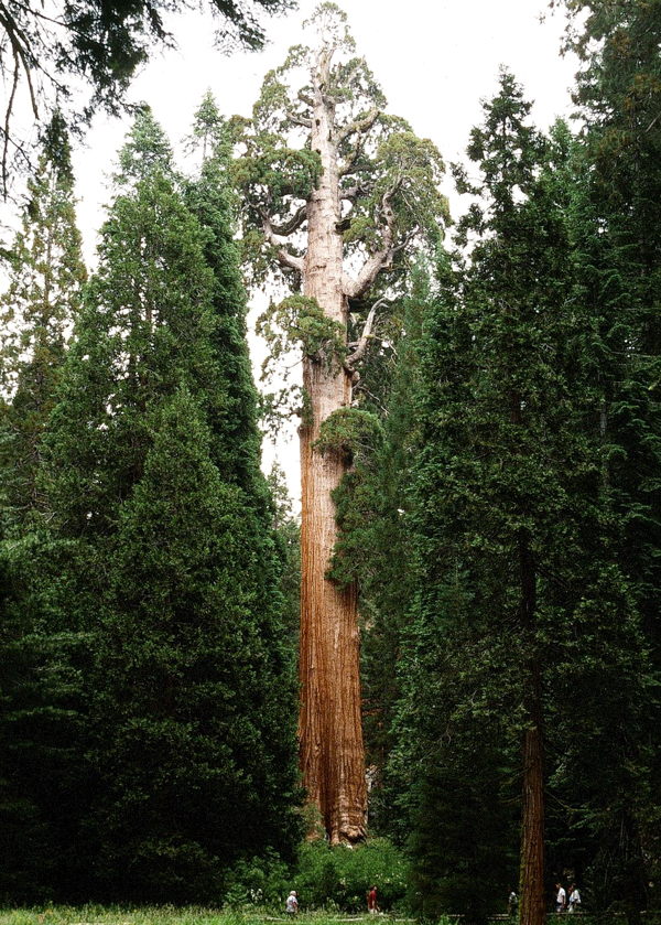
Turning onto Highway 180, we stopped at the Grant Grove and saw the "General Grant Tree".


The "General Grant Tree" in the Grant Grove in Kings Canyon National Park, California.


Even the parking lot was bordered by huge specimens.


I parked the car in front of one to give it perspective.


We followed Highway 180 down to Fresno and then drove about three hours northwest to Vallejo, where we spent the night at a Motel 6.